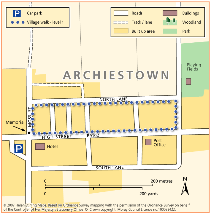
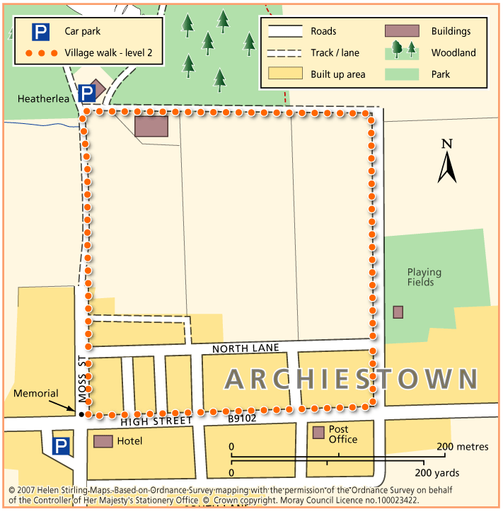
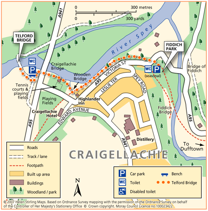
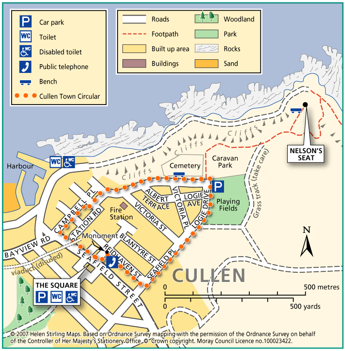
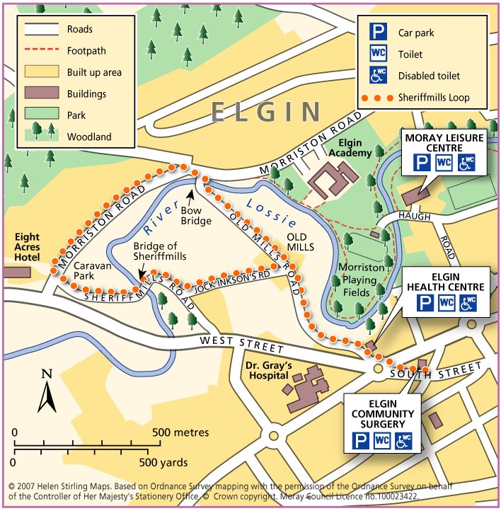
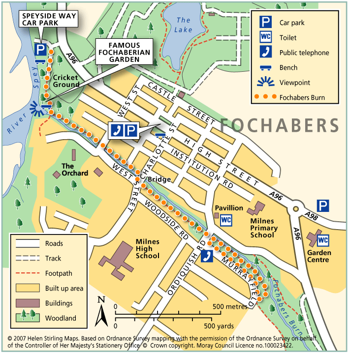
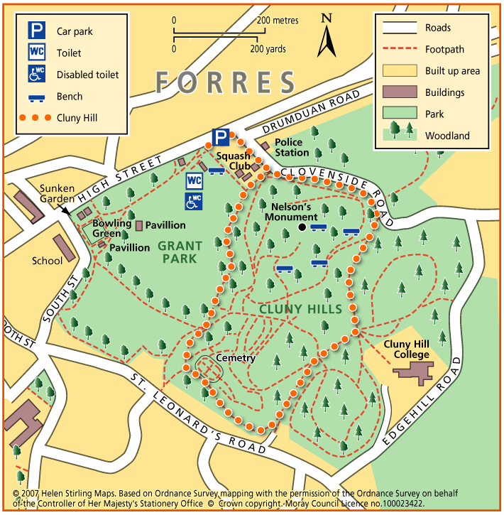
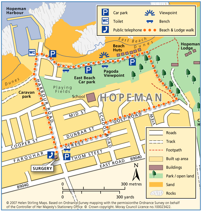
Aberlour – River Spey North Bank

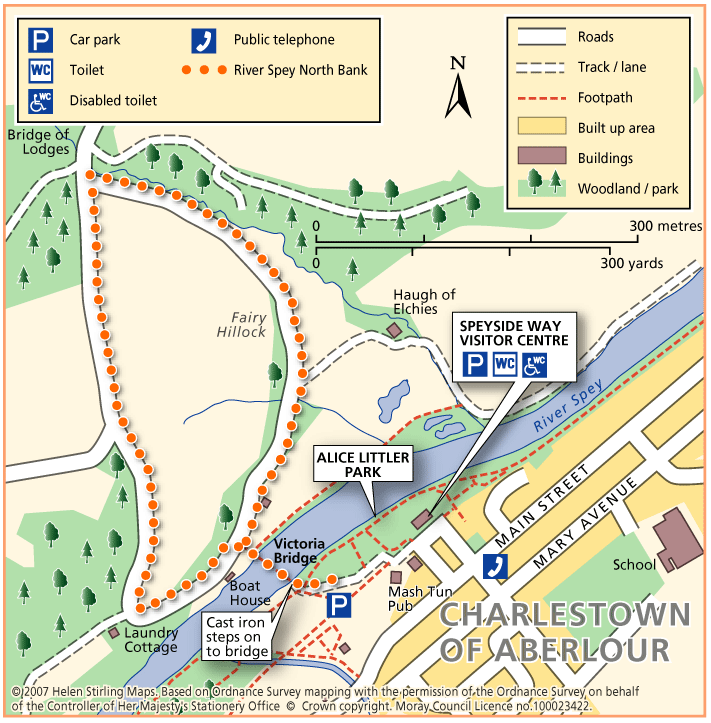
This circular route crosses the River Spey at the Victoria Bridge and follows tracks through beautiful wooded countryside. There are some long moderate inclines. There is a flight of cast iron steps to negotiate getting on to the bridge from the car park, making it unsuitable for wheelchairs and buggies.

  • Accessibility: Accessible for all with care

    May be suitable for wheelchairs and buggies with care if joined from the highest point near 'Bridge of Lodges'

  • Terrain: Varied surfaces

    Estate tracks, short tarred section.

  • Gradient: Mixed gradient

    Long moderately steep incline / decline.

  • Barriers: Some barriers

    Steps onto the bridge.

Archiestown – Village Walk

This circular walk round Archiestown includes some dirt tracks and fairly exposed sections which make it unsuitable for wheelchairs and buggies. It gives outstanding views of the surrounding countryside but some parts will be very muddy in wet weather and there are sections with no pavements, so care is needed along the roads.

  • Unsuitable for wheelchairs and buggies
  • Terrain: Varied surfaces

    Mixture of Tarmac paths and gravel tracks. Can be muddy in wet weather. Can also be quite exposed.

  • Gradient: Undulating

    Some gentle inclines and declines.

Buckie – Round Rathven

This circular walk has some great coastal views over the Moray Firth and open countryside. The walk can be shortened by cutting along the path opposite Moray View Court.

  • Unsuitable for wheelchairs and buggies
  • Paved footpaths & roads
  • Short steep sections
  • Barriers: Some barriers

    Walking on road in places.

  • Partly signed

Craigellachie – Telford Bridge

This is a linear walk along level paths, which include grass tracks and so is not suitable for wheelchairs and buggies. It follows part of the Speyside Way and has beautiful riverside views to the famous Thomas Telford metal bridge. There are benches in the car parks at both ends of the walk and seasonal toilets in Fiddich Park.

  • Unsuitable for wheelchairs and buggies
  • Terrain: Varied surfaces

    Compacted earth and gravel paths with some grass sections. Timber bridge. The path also passes under the road bridge.

  • Generally level
  • Partly signed

Cullen – Town Circular

Cullen is built on a hill and this circular town walk has a few steep slopes. The surfaces are good and it is suitable for wheelchairs and buggies, although it will be hard work on the slopes. There are toilets at the start and benches along the route. The views will be worth it! This walk can be extended to follow the path to Nelson’s Seat.

  • Accessibility: Accessible for all users

    The extended walk to Nelson's seat is not suitable for wheelchairs or most buggies.

  • Terrain: Paved footpaths & roads

    Gravel and grass paths on extended route to and from Nelson's Seat.

  • Gradient: Short steep sections

    Long, fairly steep descent from the town square under the viaduct, leading to a short steep section at Campbell Place. There is also a short steep decline from Reidhaven Place back down into the square.

  • No barriers
  • Fully signed

Dufftown – Town Walk

Dufftown is built on a hill and surrounded by hills, giving great views of the countryside but challenging to walkers. The Town Walk includes some inclines, but is all on good pavements and is suitable for wheelchairs and buggies.

  • Accessible for all users
  • Paved footpaths & roads
  • Undulating
  • Fully signed

Elgin – New Elgin Circular

This is a circular walk, which starts in Edgar Road and loops round south Elgin. It is all on good pavements and is suitable for wheelchairs and buggies.

  • Accessible for all users
  • Paved footpaths & roads
  • Gradient: Generally level

    Mainly level with some steady inclines and declines.

Elgin – Seafield Circular Walk

This circular walk follows part of the National Cyclepath into Cooper Park. The surfaces are good and suitable for wheelchairs and buggies, although there is an incline on Waterside Street. There are toilets and refreshments in the Library, on the other side of the Park.

  • Accessible for all users
  • Paved footpaths & roads
  • Generally level
  • No barriers

Elgin – Sheriffmill Loop

This circular walk takes you along quiet roads, which head out to the west of Elgin past some beautiful old buildings. The route is along good paths and roads, and is suitable for wheelchairs and buggies, although some of the route (Old Mills Road and Jock Inkson’s Brae) has no pavements and care is needed when walking along the road.

  • Accessibility: Accessible for all with care

    Take care on road sections without pavements.

  • Gradient: Undulating

    Some gentle inclines / declines.

Fochabers – Fochabers Burn

This walk follows the Burn from one end of Fochabers to the other and back again. The track can be muddy in places if there has been a lot of rain. There are benches at the start and also beside the bridge at West Street.

  • Accessibility: Unsuitable for wheelchairs and buggies

    Unsuitable for Wheelchairs and buggies, but can go as far as the viewing platform at the Famous Fochaberian Garden.

  • Terrain: Gravel path

    Gravel and earth paths, so can be muddy when wet. Can also be long grass and overhanging vegetation at the side of the path.

  • Generally level
  • No barriers

Forres – Cluny Hill Path

This is a circular route on good paths with 1 steep road section at the start but then relatively flat. The walk is under a tree canopy most of the time. In autumn and winter the fallen leaves can be knee high! You can extend the walk by joining other paths round the hill.

  • Suitable for buggies but not wheelchairs
  • Terrain: Paved footpaths & roads

    Tarmac and gravel paths - can be muddy.

  • Gradient: Generally level

    One steep road section, then generally level.

Hopeman – Beach and Lodge Walk

This is an extension of the Level 1 Beach Walk, following the coast path past the beach huts and turning inland up Lodge Lane.

  • Unsuitable for wheelchairs and buggies
  • Terrain: Varied surfaces

    Mainly tarmac pavements and paths, but gravel section at Lodge Lane. Care to be taken on Lodge Lane, which can be muddy in wet weather.

  • Gradient: Short steep sections

    Steady incline up lodge lane. Relatively level elsewhere.

Keith – Cuthil Park Circular

This is a circular walk round Keith, following the little lanes that criss-cross the town. The surfaces are suitable for wheelchairs and buggies and the route is fairly level apart from a steady climb from Turner Street to Cuthill Park. There are benches at the start and at Cuthil Park.

  • Accessible for all users
  • Paved footpaths & roads
  • Gradient: Undulating

    Steady climb from Turner St to Cuthil Park. Relatively level elsewhere.

Keith – Kynoch Park Circular

This is a circular walk linking Reidhaven Square to Keith Community Centre. There are benches in the Square and also at the Community Centre. Pavements are good and it is suitable for wheelchairs and buggies. This walk can be added to the Horse Market Circular to make a Level 3 walk of just over 2 miles.

  • Accessible for all users
  • Paved footpaths & roads
  • Gradient: Generally level

    Mainly level, but a gentle incline at School Road.

  • No barriers

Keith – Simpson Memorial Park

This is a circular walk which takes you round Simpson Memorial Park. It is mostly on pavements and good paths, apart from a short stretch of grass path which could be muddy in the wet. It is suitable for wheelchairs and buggies if dry and is fairly flat apart from the section along Drum Road.

  • Accessibility: Accessible for all with care

    Can be used by buggies and wheelchairs during dry weather.

  • Terrain: Varied surfaces

    Mostly on tarmac pavements and paths. Grass path at Simpson park - which can be muddy in wet weather.

  • Gradient: Undulating

    Long but steady climb up Drum Road. Relatively flat elsewhere.

Keith – St Rufus Park Circular

This circular walk includes some very interesting parts of Old Keith, Strathisla Distillery, Milton Tower and Keith and Dufftown Old Railway Station. There are some steep sections, which would make it unsuitable for wheelchairs. There are benches at the start and along the way.

  • Unsuitable for wheelchairs and buggies
  • Terrain: Varied surfaces

    A combination of roadside pavements, a tarmac footpath through the cemetery and a long section of gravel farm track. Take care on the track which is rather potholed and can be muddy in wet weather.

  • Undulating

Lossiemouth – Harbour Circular Walk

This is an extension of the Harbour Walk, up to James Square. It includes a small steep slope down Hill Street.

  • Accessibility: Accessible for all with care

    Suitable for wheelchairs, with care on slope.

  • Paved footpaths & roads
  • Gradient: Short steep sections

    One short but steep section of decline.

Lossiemouth – Skerry Brae Walk

This is a circular walk on good footpaths and is suitable for wheelchairs and buggies. The route can be extended to include the Golf Course Walk, which would then be a Level 3 walk of 2 ¼ miles and take between 45 and 60 minutes.

  • Accessibility: Accessible for all with care

    Suitable for wheelchairs and buggies, though be aware of the fairly steep section.

  • Paved footpaths & roads
  • Gradient: Short steep sections

    Fairly steep but steady decline at Tullochs Brae. Relatively level elsewhere.

Mosstodloch – Gordon Baxter Way

This is a circular, level walk with good views of the countryside. The tracks can be muddy if wet and this walk shouldn’t be undertaken on a windy day as it is exposed in places.

  • Unsuitable for wheelchairs and buggies
  • Terrain: Varied surfaces

    Farm tracks and tarmac. Can be muddy.

  • Generally level